We speak with Yossef Rapoport about his work on a new book exploring early Islamic map-making, exploration and discovery

Could you tell us a little about how the Book Of Curiosities was discovered and how you became involved with it?
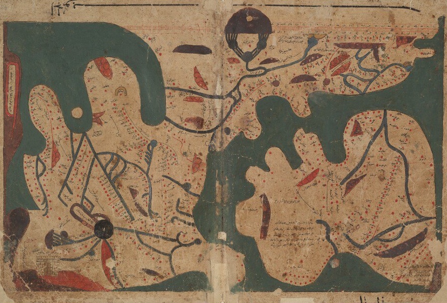
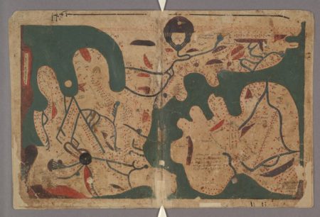
The story of this book is really a story of discovery. And it’s genuinely a story of discovery in that this manuscripts were lost for a millennium. Emilie [Savage-Smith] discovered them or as Emilie likes to say, the manuscripts discovered her. They called her from Christie’s because she’s a senior specialist in the history of Islamic science, back in 2000, and said ‘we have this manuscript and we don’t know what to do with it and it’s already in the catalogue, but we think we may have undervalued it. She just happened to be in London that week so she stopped for a visit there and she realised this is something special. So, she took some photos and showed it around and realised this was a series of maps that are not only unique, but of supreme value. There was one map with a scale on the top and we know of no other map from any other civilisation with a scale that early in history. It took time, but it’s been identified as an 11th century treatise.
Within a few days they realised at Oxford that this is a manuscript of great significance. And this manuscript was really not known before. The treatise was known, but it was copied without the maps and so there wasn’t much attention given to it. She tells the story in the book in the first chapter of the discovery and how she campaigned to get it into public hands to be bought by the Bodleian Libary. Eventually at Christie’s a private dealer bought it, but it was bought by the Bodleian after a fundraising campaign.
This was 20 years ago so I was younger and I was recruited as a research assistant for the project, which was funded by the National Lottery Heritage Fund and who helped the purchase by the Bodleian and then we worked on the translation. It was published online as well as in a hefty volume.
What can you tell us about your new book with Prof. Savage-Smith?
Our book is not a translation. It’s a book that tries to explain why this is so important. We’ve tried to say that it’s important in three main ways. I should say that we now know from internal evidence that it was written in the first half of the 11th century in Cairo in the capital of a Shia dynasty and the book progresses from the outer edges of the universe, from the stars, slowly coming to the planets and constellations and into Earth. The first part describes the sky and the second part describes the Earth. So, it’s significant firstly because its description of the sky is really quite comprehensive and shows a lot of how people who were not astrologers necessarily or mathematical astronomers, showed the relationship between the sky and the Earth. In this book everything that happens in the sky and in the heavens, every star movement, affects what happens on the Earth. What Emilie does very well in the book is show how the picture of the sky complements so well the picture on the Earth. There’s a nice symmetry.
The second part of the significance of the book is the history of global communication. It’s very surprising because you see that this book, which was composed in Cairo, has a map of the trade route between central India and China along the coast of East Africa. And for the Mediterranean it has a wonderful map showing how the Mediterranean was not cut between North and South, between Muslims and Christians, from the perspective of Cairo it was cut at Sicily. So the East of the Mediterranean it knew a lot about, and also the Byzantine coast and what is now Greece and it knows in very fine detail how to navigate it. But it knows nothing of Sardinia or Majorca or anything like that. there’s nothing on Spain, even though it was Muslim at the time.
Finally, it’s how these maps are so unique. They show so much about how Muslims specifically saw the world and how they depicted the world in maps in that period. That includes the map on the cover which holds some traces of mathematical plotting, using coordinates to plot and it’s clearly drawing from the Hellenistic tradition of the great geographer Ptolemy. This entire book is in dialogue with a Greek heritage.
There are a whole set of maps, like the one on the cover, the map of the Indian Ocean and others, that show how sailors navigated before the compass. We really have no evidence of that in maps or diagrams.
We wanted to ask specifically about their design, because they’re unlike any version of cartography we would recognise today. How would they have been read?
First of all the book as we have it would not have been aboard a ship. But how did they read it? In a way they have a lot of little labels, but most of the book tries to avoid complex figures. So the lines are simple, it’s like a diagram that you have without orientation. They know where North and South are, they know directions and even distances, approximately, but the map maker actually says I could have done it with technical devices and calculated how to draw the map, but then how could anyone read it? Because then you would not have the space to right the labels. Because you do not have a compass yet, because you’re working with very crude navigation with the stars and the sun and so forth, what you really want to know is how to plan a journey. For that, what you need is a diagram that sets out in sequence the stages of your journey for what comes next. So it’s a diagram and in some ways it could be just a text, but a diagram, like this oblong shape, allows you to say things like Jaffa is just before Caesarea. But I can also know that if I go west I go to Cyprus. I can see some things, but I can’t see everything so a map, even a simple diagram, can create connections that you don’t see in a written text. But it’s not meant to be mathematical in any way.
Is it almost like a visual version of how you might give someone directions by telling them landmarks to look out for on their journey?
There is an element of that, but think of the Tube Map. This is a closer example because a map doesn’t have space for the directions you describe. You can’t say on a map ‘you go past the church and turn left’. There’s no space for that and they’re very worried about space and how to fit it all in. So the Tube Map is a good example because you simplify and make it into a diagram and the reason is the same, because when we are underground we don’t have the navigation tools we have overground. A medieval person would be in a bit of a similar situation. They would know generally where is North and where is South, but they wouldn’t be able to measure it in precise way. Even if you make the map precise, the user doesn’t have the tools to measure it.
Were there references to the book that let you know it was around? Was there a sense of its absence?
No, because we had a manuscript that was unillustrated. Only texts. It just shows how rich the Islamic tradition is. There’s even a manuscript that was written, not in Arabic, but in Assyrian, which is an iteration of Arabic. There’s one in Aleppo and one in Germany. But because the maps were not there no one really gave them much attention. There are tens of thousands of manuscripts still not covered and published from the Islamic world. There’s so much more to be written.
 How do these maps compare to what was going on in cartography in the rest of the world at that time?
In this period, in the 11th century, the big difference is that European maps are infused with religion, with theology. They tended to have Jerusalem at the centre and many maps show, for example, where the Garden of Eden is. In the Book of Curiosities, theology has no place in these maps. This is a scientific treatise and it also doesn’t try to tell a story. It’s not just that it’s not theological, it doesn’t have a narrative in the map. A European map of the same time would have told a story in how you go from Paris to the Holy Land and this is what happened to the Israelites here.
What I don’t want to over-emphasise is that this is more usual than the European maps. I just want to say that the outlook of these maps is not theological and I would say they owe much more to the Hellenistic traditions than the European and I think that’s true for Islamic civilisation in general. It draws much more from the Greek traditions in many ways than just maps. The other thing that’s surprising given that it’s an Islamic manuscript is that this is a maritime treatise. The most unique contributions are maps of the seas and even of port cities. Europe that this time in the 11th century, at least in cartographic terms, has not discovered the sea. It’s discovered the sea, but not thinking in terms of sea lanes, which will come in the 13th century. Europeans with the aid of the compass, I believe, begins to create maps that are very accurate based on navigation. But that happens two centuries later. These maps are fantastic because they show how sailors thought of navigation before the compass; how they imagined the space around them before the compass.
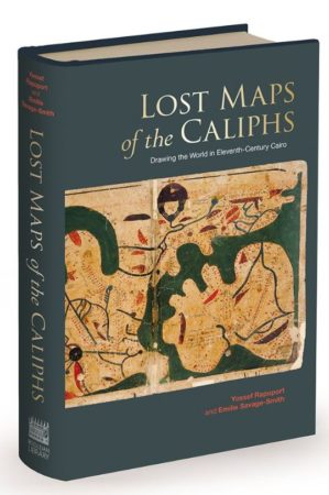
Lost Maps of the Caliphs: Drawing the World in Eleventh-Century Cairo by Yossef Rapoport & Emilie Savage-Smith is available now
Subscribe to All About History now for amazing savings!