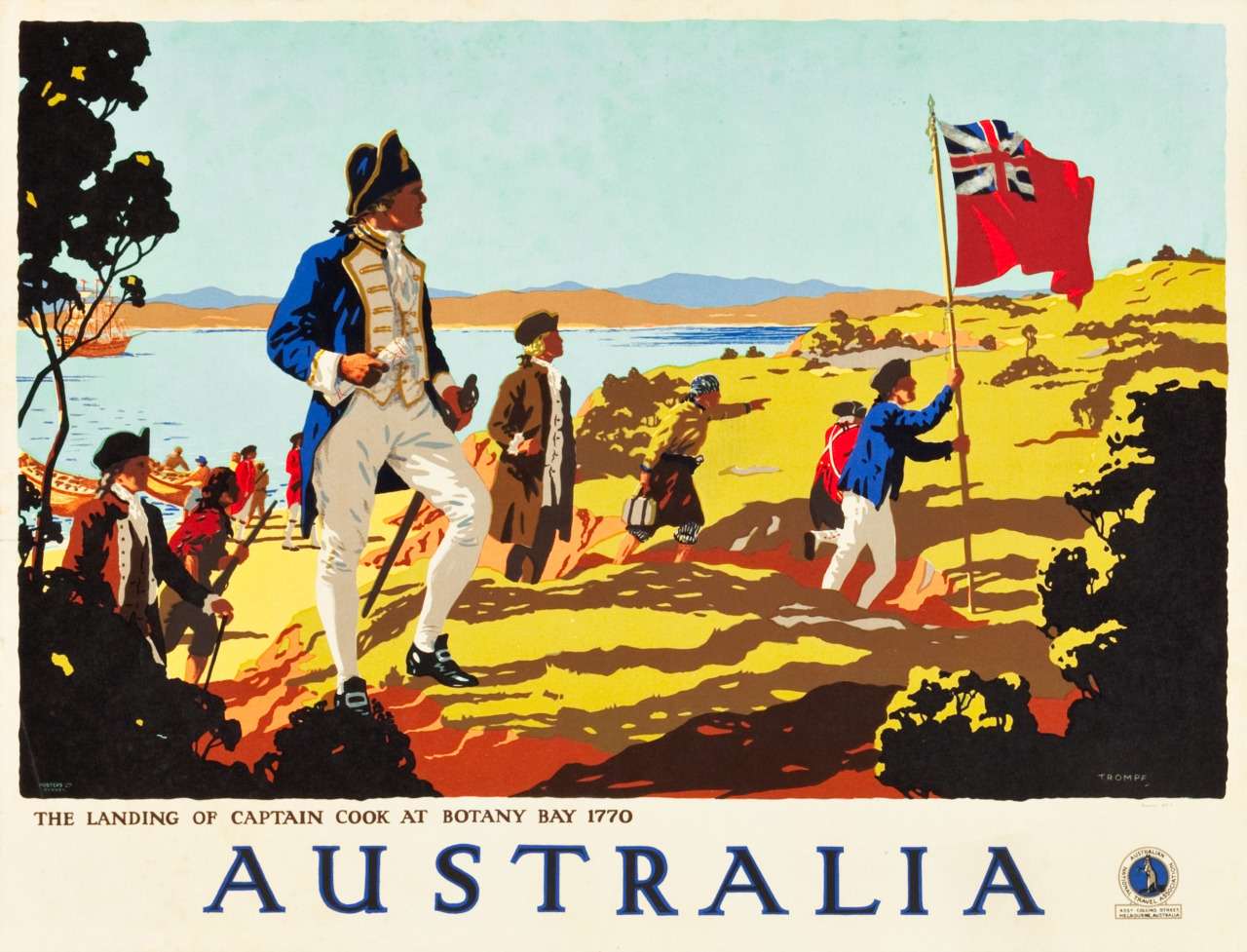
On 20 August 1770, the flag of Great Britain was hoisted over the silver sands to flutter in the breeze. Three volleys were fired by the landing party, and then answered by the Bark Endeavour, moored in the bay.
James Cook and his crew had been at sea for 724 days with Plymouth a distant memory, and it had been 141 days since they had left New Zealand behind. Less than 100-strong, a tiny ship in a vast ocean, they had mapped the coastline, every island and inlet, before tacking west to Van Diemen’s Land, then north in search of the eastern coast of Terra Australis Incognita – the unknown land of the south – promised in his sealed orders.
Ostensibly in the Pacific to witness the rare transit of Venus across the sun, their’s was a swashbuckling secret mission in the name of discovery, with a royal warrant to claim unsettled lands for the crown, and record alien sights and skies for science. When explorer, astronomer and enlightenment hero Lieutenant James Cook stepped ashore and claimed the great southern land for Britain – naming the whole eastern chunk of this vast continent New South Wales in the process – he wasn’t discovering a new world so much as he was meeting an old friend.
The dream of Australia had dominated the European exploration of Asia for 400 years, and had been a myth of Atlantean proportions for much longer. Cook wasn’t the first to arrive, flag in hand, and stretched out before him was a road paved with shipwreck, war, spice and piracy, but first, there had to be the idea itself.

The Ancient Greeks and the Great South Land
15,913 kilometres (9,888 miles) and well over 1,000 years away, Pythagoras set light to Cook’s imagination. Around 530 BCE, the Methuselah of mathematics had decamped to Croton in modern Italy to escape the tyranny in his Greek island homeland of Samos. Travelling widely from Egypt to India before founding his school of ideas and gathering his followers, he put his experiences to work, devising the theorem that bears his name, and a slightly less well-known one about the musical values of various lengths of string.
Pythagoras was also credited with the notion that our world was a sphere, and so there had to be a vast landmass to the south to balance this orb. Two centuries later, Aristotle advanced this theory based on the circular shadow of the Earth during a lunar eclipse and the changing places of constellations the further south you sailed. In the wake of Aristotle’s studies of the night sky, the Roman geographer Pomponius Mela (1st century) produced maps dividing the world into northern and southern zones, and later the Greco-Roman astrologer, astronomer, geographer and all-round busy thinker Claudius Ptolemy (90–168 CE) compiled all the knowledge that he could of the world’s regions into his immense Geographia, adding that the route to the great southern land was no doubt impassible due to “monstrosities.”
The idea of this new expanse – Terra Australis – took root in the foundation of Renaissance geography and cartography, until every map came with a vaguely defined great southern land. Just as Cook’s 1768 mission – a fact-finding expedition for the Royal Society of London – came with its sealed orders to increase the reach of the British Empire, it was politics and economics that set his spiritual predecessors off on their voyages of discovery.

Europe’s Empires Reach to the Pacific
In 1368, the mighty Mongol Empire, that stretched from Eastern Europe to the Sea of Japan, collapsed, ruling out the overland journey to the riches of China and India. The surprisingly cordial relationship between the Khan and the Pope was replaced by tensions between Christian Europe and the rising Islamic Ottoman Empire, which closed the overland routes to the east. Their hand forced by demand for spices, silk, tea and porcelain, the mercantile nations – the Portuguese and Spanish at first, and then the Dutch, French and English – began to look for sea routes into the Indian Ocean and beyond.
While the European superpowers began to look upon their maps and globes anew, the powerful Tamil merchant dynasties of Sri Lanka established their own maritime trade empire that stretched its fingers across South East Asia between the 9th and 14th centuries. Their holds stuffed with the luxuries of India, and the traditional Tamil proverb “cross the oceans and acquire gold” on their lips, they made their presence felt through art and architecture in Thailand, Java, Malaysia, Vietnam and Cambodia. By the 18th century – though their once great empire had declined, replaced by colonial Portuguese, and then Dutch and British – Tamils were trading with the European settlers in New Zealand and Australia.
Yet there’s evidence to suggest that they’d been there before: a 14th century ship’s bell, beautifully inscribed in Tamil, found in 1836 being used as a Māori cooking pot.
Now locked in a mercantile Cold War, following a belligerent race for territory and trade across the gradually opening globe, the Portuguese and Spanish reached a frosty impasse with 1494’s Treaty of Tordesillas, dividing North and South America between them, and then 1529’s Treaty of Zaragoza which divided Asia.

The Portuguese and La Austrialia del Espíritu Santo
The Portuguese crown had rolled across East Africa, India and into Malaysia, with the city of Malacca and the nutmeg and clove-rich Spice Islands of the Banda Sea at the centre of their interests. They even set up a trading post on the island of Timor in 1590, only 720 kilometres (448 miles) from what is now Darwin in the Northern Territories.
Claiming much of Asia as their own and setting the rival Spanish up for a future toehold in the spice-free Philippines, and precious little else, the Zaragoza line neatly bisected New Guinea, and though they may not have known it, also that fabled Terra Australis Incognita.
With the support of Pope Clement VIII and King Phillip III, Pedro Fernandez de Queirós set off from Peru in 1603 with three ships to find and claim Terra Australis for Spain. Leaving navigation “to the Will of God” and landing on Vanuatu, just west of Fiji – mistaking it for his prize – he dubbed it La Austrialia del Espíritu Santo, the Southern Land of the Holy Spirit, before attempting to found a colony called Nova Jerusalem (and a holy order, the Knights of the Holy Ghost, to protect it). Nova Jerusalem collapsed ignominiously through the hostility of the Ni-Vanuatu and his own crew.
Ironically, it was actually de Queirós’s second-in-command, Luís Vaz de Torres, who came the closest to realising his dream. Separated from de Queirós, de Torres led the two remaining ships to Manila. When winds forced him south of New Guinea instead of north, he and his crew became the first recorded seamen to navigate the strait that now bears his name, dividing New Guinea in the north from Australia in the south. Though he may not have understood the significance of the Cape York Peninsula at the time, his voyage is the most credible Spanish claim to the discovery of Australia.

While de Queirós’s divine mission scattered, his masters fared little better. In 1578, the status quo was rocked when King Sebastian I of Portugal died without heir, prompting a Spanish invasion in 1580 that saw King Phillip III’s father unite both thrones. Spain gained Portugal’s colonial possessions, and those increasingly vulnerable and far-flung Portuguese colonies gained Spain’s multitude of enemies. Over the next two decades, England, France and the newly independent Dutch Republic snapped at the Iberian Union’s heels in North America, South America, India, Africa and South East Asia – tearing off chunks of land, piece by bloody piece.
The Dutch Enter the Race
In 1605, the Duyfken (‘little dove’), its eight cannons blackened by Spice Islands skirmishes with the Portuguese, sailed from Java, newly fallen under Dutch influence, to explore the coast of New Guinea on behalf of the Dutch East India Company (VOC). Captained by Willem Janszoon, he became the first recorded European to set foot on Australia in 1606, thinking it was the continuing western coastline of New Guinea (missing the Torres Strait altogether – and it would take Cook, over a century later, to conclusively prove that Australia was a separate landmass).

Finding it swampy and inhospitable, the crew of the gently named Duyfken proved themselves anything but, as amicable early encounters with the Indigenous Australians turned sour when the Dutch abducted some of their women, prompting a cycle of attack and reprisal that forced them back to sea.
Janszoon was followed in 1616 by Dirk Hartog on the Eendracht’s maiden voyage. Becoming separated from a VOC fleet crossing the Cape of Good Hope, he took advantage of the ‘Roaring Forties’ – powerful westerly winds that could cut a journey shorter by months – and whether by accident or design, he shot across the Indian Ocean far more southerly than was usually safe.
The Eendracht reached Western Australia and left a flattened pewter dinner plate as its testimony. Thanks largely to VOC’s enthusiasm for speed over lives – the company insisted its captains take advantage of the Roaring Forties, regardless of the danger – the Dutch caught sight of Australia many times over the next few decades, gradually shading in more and more of their maps, with many more of them left smashed against the rocks.
The oldest of these wrecks was the Tryall, sunk in 1622 en route to Java from Plymouth and captained by John Brooke. The Tryall represented an achievement by which Cook could scarcely be inspired – the first Englishman to clap eyes on the great southern land was also the first European to sink within her treacherous currents.
While recklessness had catapulted Europeans onto antipodean shores, the meticulous Abel Tasman was a different breed. He had the ship’s carpenter swim ashore to plant the flag, rather than risk a ship on unknown rocks, to claim Van Diemen’s Land in 1642 (now known as Tasmania) in honour of Anthony van Diemen, the governor-general of the Dutch East Indies.

Van Diemen had earned that privilege – under his stewardship, the Dutch East Indies became a centre for frantic map-making and territorial expansion, and Tasman was entirely on message with his employer’s way of doing things. With so much intricate detail captured through drawings, diaries and maps on his voyage to Tasmania, and then across the Tasman Sea to become the first European to reach New Zealand, Cook used his writings over a century later as a reference, landing in Poverty Bay to claim it for Britain.
Tasman returned to Australia once more in 1644, mapping the northern shores and choosing the name that would supplant Terra Australis – New Holland. It would survive both Cook and the colony of New South Wales, and only 180 years after Tasman first uttered the name ‘New Holland’ would it be officially replaced by ‘Australia’.
The English Pirate and His Dubious Celebrity
If Abel Tasman was the example that James Cook followed, then William Dampier was the (somewhat dubious) legend that Cook aspired to.
A British buccaneer from humble beginnings, he had circumnavigated the globe a record-breaking three times, writing the bestselling A New Voyage Round The World in 1697 and rescuing the man who would become Daniel Defoe’s Robinson Crusoe.
His adventures impressed the British Admiralty so much that in 1699 – 29 years before Cook’s birth – Dampier was given the helm of HMS Roebuck, and a commission to explore New Holland and uncover the eastern coast that would later fall to Cook. Dampier collected an unprecedented catalogue of Australian plants and wildlife before the rotting Roebuck began to take on water. After some slipshod repairs allowed them to return home – the east coast mission abandoned – the unlikely naturalist was later marooned on Ascension Island.

Court-martialled for losing the vessel in his charge and deemed “unfit to command any of HM’s ships, Dampier promptly returned to the life of a sanctioned Jack Sparrow, but not before releasing A Voyage To New Holland in 1699, rich with detail of flora, fauna, rocks and even prevailing winds.
Though Dampier had failed in his most strategically important goal – and lost his ship doing so – his voyage pre-empted a paradigm shift, not just in British thinking but in French too. However, this took nearly another century to materialise, and it would again be politics and profits that saw navigators, botanists, explorer and East Indiamen dispatched with flags for planting.
The colonial horse-trading and nation-swapping that closed the Seven Years’ War in 1763 saw Spain, France and Britain ease into a stand-off far messier and more convoluted than Portugal and Spain in the 15th and 16th centuries, and once more the booming empires had nowhere left to expand but into the unknown.

Cook Comes of Age
Naval officers – who, like Cook, had proven their worth in the far-flung theatres of the last war – were dispatched to the Pacific with increasing regularity by a conflict-scale navy with a peacetime surplus of ships, men, money and experience. In quick succession, the Admiralty sent Commodore John Byron in 1765 and then Captain Samuel Wallis in 1766 on the HMS Dolphin, and Captain Phillip Carteret on the HMS Swallow in 1766, and then Cook himself in 1769 – all spreading the red, white and blue across a swathe of Pacific islands, the promise of Terra Australis never far from their minds.
As James Cook and his predecessors raced south just as Tasman and Torres had done before them, their French counterparts at their heels, the map of Australia would continue to be shaded in inch by inch. Whether their sails were buffeted by economic, political or imperial forces as much as by the Roaring Forties, their achievements remain a triumph of reason and discovery.
When Cook finally felt Australian sands crunch beneath his feet, it’s true that he was building on older expeditions – the writings of Tasman, Dampier and, more recently, Wallis at his hand – as well as the ideas at its heart stretching back to Ancient Greece, but his discoveries would become the foundation for a colony, and eventually a nation.
It would be many more years before European settlers knew for a fact that the land Cook had claimed as New South Wales was connected to New Holland, and wasn’t connected to Van Diemen’s Land, just as it took Cook to prove that these scattered chunks of a much grander country weren’t connected to New Zealand or New Guinea (thanks in part to the Spanish keeping Torres’ voyage to themselves).
Their vessels cutting across unknown oceans and into alien horizons, these men – this cast of thinkers, seafarers, pirates and traders from across centuries – closed a chapter in Australia’s long history, and for better and for worse a new one was about to begin.
For more on the world’s greatest explorers, pick up the new issue of All About History or subscribe now and save 25% off the cover price.